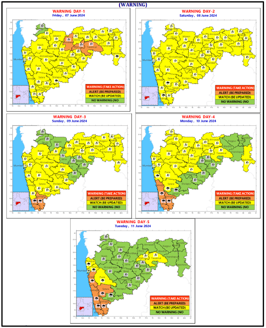
Heavy to very heavy rainfall warning over parts of Maharashtra during next 5 days | IMD

Due to gradual strengthening of westerly winds in association with south west monsoon, a gradual increase in rainfall activity is expected over parts of Maharashtra during next 5 days.

Widespread rainfall activity with heavy to very heavy rainfall is expected over Konkan and adjoining ghat areas of Madhya Maharashtra during the above period. Thunderstorms accompanied with lightning and gusty winds is very likely to occur during the above period.
Weather Systems
A shear zone runs roughly along 16°N in lower & middle tropospheric levels
A cyclonic circulation lies over south Telangana & neighborhood, and a trough runs from south Maharashtra to southeast Arabian off south Kerala in lower tropospheric levels.
Districts on High Alert
- Very Heavy to Extremely Heavy Rainfall – Ratnagiri, Sindhudurg
- Heavy to Very Heavy Rainfall – Raigad, Mumbai
- Thunderstorm, Lightening and Gusty Wind Reaching Speeds up to 40-50 kmph – Buldhana, Washim and Yavatmal
Rest of the districts will witness thunderstorms, lightening, strong winds and moderate to heavy rainfall.
Weather Impact
- Localized inundation/flooding of low-lying areas and urban areas
- Possible uprooting of weak trees and collapse of old and unmaintained structures
- Possibility of flash floods
- Disruption to road, rail, air and ferry transport
- Local disruption of municipal services (Water, electricity etc.)
- Flow of water over low-lying roads and bridges
- Landslide/Mudslides and rock falls in vulnerable areas
- Strong wind may damage plantation, horticulture and standing crops
- Minor damage to kutcha houses/walls and huts
- Possibility of cloud to ground lightning during thunderstorm events
Action Suggested
- Avoid working in open areas and fields while thunderstorms are taking place
- Avoid taking shelter under tall trees and structures when thunderstorm is occurring
- Unplug electrical/ electronic appliances
- Immediately get out of water bodies
- Keep away from all the objects that conduct electricity
Monsoon Progress
The Northern Limit of Monsoon continues to pass through 17.0°N/60°E, 17.0°N/65°E, 16.5°N/70°E, Ratnagiri, Solapur, Medak, Bhadrachalam, Vizianagaram, 19.5°N/88°E, 21.5°N/89.5°E, 23°N/89.5°E and Islampur.
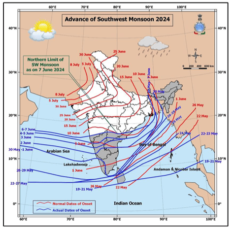
Conditions are favourable for further advance of Southwest Monsoon into some more parts of central Arabian Sea, some more parts of Maharashtra (including Mumbai), Telangana, remaining parts of Coastal Andhra Pradesh, some parts of south Chhattisgarh & South Odisha, remaining parts of Westcentral & more parts of Northwest Bay of Bengal during next 3-4 days.


